File:Orthodox parishes in Japan map.png
Original file (1,400 × 1,414 pixels, file size: 1.21 MB, MIME type: image/png)
Summary
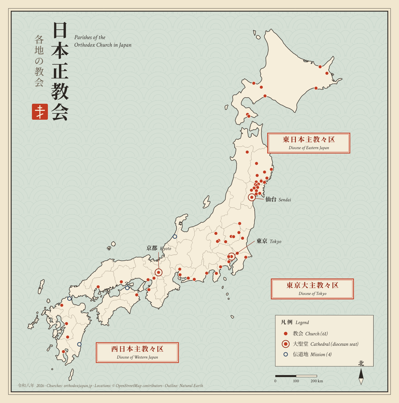
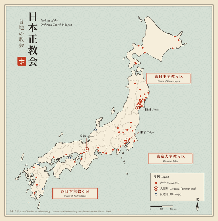
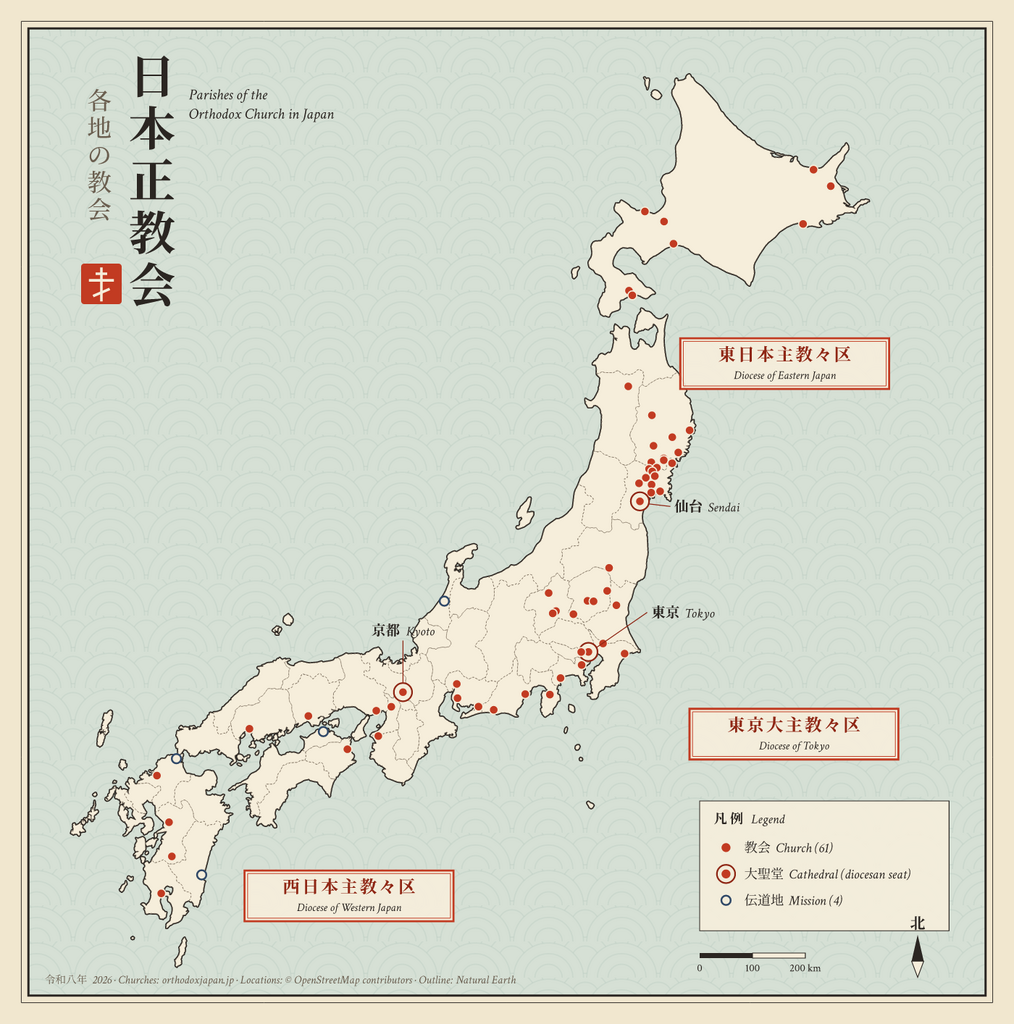
Map of the parishes of the Orthodox Church in Japan: 61 churches and 4 missions, grouped by diocese. Cathedrals (Tokyo, Sendai, Kyoto) are shown with a double ring.
How this map was made
The map was drawn by a short Perl script, not by hand and not by an image generator. The script reads geographic data and writes the SVG file directly, so every shape and dot is placed by its real latitude and longitude.
- Outline of Japan. The coastline and prefecture borders come from
 Natural Earth (1:10m admin-1 boundaries),
 a public-domain map dataset. The script takes the latitude/longitude points of each
 prefecture, converts them to positions on the page (an equirectangular projection,
 true to scale at 38°N), and simplifies them slightly to keep the file small.
 Okinawa and the Ogasawara Islands are left out, as there are no parishes there.
- List of churches. Taken from the official parish listings of the Orthodox
 Church in Japan at orthodoxjapan.jp
 (Diocese of Tokyo, Eastern Japan and Western Japan pages).
- Church locations. Each church was looked up in
 OpenStreetMap. Where OpenStreetMap has the church
 building itself (36 churches), the dot is placed on the building; otherwise it is
 placed at the district named in the church's official address. Every dot was then
 checked to make sure it falls inside the correct prefecture.
Sources and licence
- Map outline: Natural Earth (public domain)
- Church list: orthodoxjapan.jp
- Church locations: © OpenStreetMap contributors, available under the
Open Database License
Copyright status:
This image has been released into the public domain by the copyright holder, its copyright has expired, or it is ineligible for copyright. This applies worldwide.
Source:
File history
Click on a date/time to view the file as it appeared at that time.
| Date/Time | Thumbnail | Dimensions | User | Comment | |
|---|---|---|---|---|---|
| current | 11:46, October 22, 2026 | | 1,400 × 1,414 (1.21 MB) | Hafvindur (talk | contribs) | == Summary == Map of the parishes of the Orthodox Church in Japan: 61 churches and 4 missions, grouped by diocese. Cathedrals (Tokyo, Sendai, Kyoto) are shown with a double ring. == How this map was made == The map was drawn by a short Perl script, not by hand and not by an image generator. The script reads geographic data and writes the SVG file directly, so every shape and dot is placed by its real latitude and longitude. # '''Outline of Japan.''' The coastline and prefecture borders come... |
You cannot overwrite this file.
File usage
The following file is a duplicate of this file (more details):

- File:Orthodox parishes in Japan map.png from a shared repository

There are no pages on Orthodox Wiki Commons that link to this file or image.
Check other language Orthodox Wiki sites.
